Helicopter overflight of a fast-moving lava flow emerging from fissure 20 on May 19, at 7:52 AM HST. The flow is advancing to the southeast. Lava fountaining is visible in the background. The audio is the sound of the helicopter.
VIDEOS: LAVA NEWS
HTH 5-20-2018: Volcanologist: Effects of laze could reach 15 miles downwind
SA 5-20-2018: Presence of andesite means the lava that came up in fissure 17 could have come from magma stored in an underground reservoir dating back to before the 1955 eruption, possibly as early as the 1924 eruption or an eruption in 1840.
HTH 5-20-2018: Two lava flows enter the ocean off Highway 137; Coast Guard enforcing ‘safety zone’
HTH 5-20-2018: Lava crosses Highway 137 and enters the ocean in lower Puna

Lava entering ocean at MacKenzie St Park morning of May 20, 2018 PHOTO:USGS
HTH 5-19-2018: Lava flows cause brush fires to spread toward Kamaili Road; residents advised to evacuate immediately
SA 5-19-2018: Lava flow is currently heading in the general direction of MacKenzie State Park –may cross highway within 5-6 hours
HAWAIIAN VOLCANO OBSERVATORY STATUS REPORT
From U.S. Geological Survey Monday, May 21, 2018, 1:57 AM HST
KILAUEA VOLCANO (VNUM #332010)
19°25'16" N 155°17'13" W, Summit Elevation 4091 ft (1247 m)
Current Volcano Alert Level: WARNING
Current Aviation Color Code: RED
Kīlauea Volcano Summit
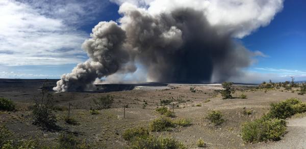
A small explosion occurred at 12:55 AM at Halema'uma'u crater at Kilauea's summit. It produced an ash plume that reached about 7,000 ft asl and was carried by the wind to the southwest.
Additional explosive events that could produce minor amounts of ashfall downwind are possible at any time.
Information on ash hazards and how to prepare for ashfall maybe found here: http://www.ivhhn.org/information#ash
* * * * *
HAWAIIAN VOLCANO OBSERVATORY STATUS REPORT
From U.S. Geological Survey Saturday, May 19, 2018, 4:13 PM HST
KILAUEA VOLCANO (VNUM #332010)
19°25'16" N 155°17'13" W, Summit Elevation 4091 ft (1247 m)
Current Volcano Alert Level: WARNING
Current Aviation Color Code: RED
Kīlauea Volcano Lower East Rift Zone
Eruption of lava and ground cracking in the area of Leilani Estates subdivision continues.
Beginning yesterday and into today, the rate of lava eruption has increased. Fissure 17 is weakly active now, and Fissures 16-20 have merged into a continuous line of spatter and fountaining. Flows from the consolidated Fissure 20 crossed upper Pohoiki road late yesterday afternoon and continued flowing southward. This afternoon two flows from the merged fissure complex have joined less than a mile from the coast and continue to flow southward between Pohoiki and Opihikao Rds. The lava flow from Fissure 18 is stalled. It is unknown whether the flows will continue to advance, or stop, and new lava flows are likely given the rate of activity seen at the rift zone. Volcanic gas emissions remain very high.
For recent maps of activity, see: https://volcanoes.usgs.gov/volcanoes/kilauea/multimedia_maps.html
Additional ground cracking and outbreaks of lava are possible in the area. Residents downslope of the region of fissures should heed all Count of Hawaii Civil Defense messages and warnings.
Magma continues to be supplied to the lower East Rift Zone; however, a GPS instrument near the Lower East Rift Zone is no longer moving suggesting that the rift zone is no longer inflating in this area. Elevated earthquake activity continues, but earthquake locations have not moved farther downrift in the past couple of days.
USGS/HVO continues to monitor the lower East Rift Zone activity 24/7 in coordination with Hawaii County Civil Defense, with geologists onsite to track ongoing and new fissure activity and the advance of lava flows.
Kīlauea Volcano Summit
Small ash emissions from the Overlook crater have occurred intermittently today. Moderate trade winds were blowing to the southwest and noticeable ashfall may happen in downwind locations.
Additional explosive events that could produce minor amounts of ashfall downwind are possible at any time. Volcanic gas emissions at the summit remain high.
For forecasts of where ash would fall if such an explosion occur, please consult the Ash3D model output here: https://volcanoes.usgs.gov/observatories/hvo/activity_2018.html
Information on ash hazards and how to prepare for ashfall maybe found here: http://www.ivhhn.org/information#ash
* * * * *
HAWAIIAN VOLCANO OBSERVATORY STATUS REPORT
From U.S. Geological Survey Saturday, May 19, 2018, 9:16 AM HST
KILAUEA VOLCANO (VNUM #332010)
19°25'16" N 155°17'13" W, Summit Elevation 4091 ft (1247 m)
Current Volcano Alert Level: WARNING
Current Aviation Color Code: RED
Kīlauea Volcano Lower East Rift Zone
Eruption of lava and ground cracking in the area of Leilani Estates subdivision continues.
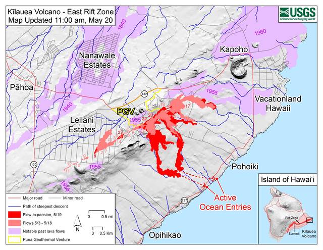
Beginning yesterday and continuing overnight, the rate of lava eruption has increased. Fountaining is occurring at Fissure 17, and Fissures 16-20 have merged into a continuous line of spatter and fountaining. Flows from the consolidated Fissure 20 crossed upper Pohoiki road late yesterday afternoon and continued flowing southward. This morning, the wide flow is very active and is advancing at rates up to 300 yds per hour. A second flow from the same fissure complex is also flowing southward between Pohoiki and Opihikao Rds. The lava flow from Fissure 18 continues to advance more slowly. Fissure 17 and its flow are still active but the flow is advancing even more slowly. It is unknown whether the flows will continue to advance, or stop, and new lava flows are likely given the rate of activity seen at the rift zone.
For recent maps of activity, see: https://volcanoes.usgs.gov/volcanoes/kilauea/multimedia_maps.html
Additional ground cracking and outbreaks of lava are possible in the area. Residents downslope of the region of fissures should heed all Count of Hawaii Civil Defense messages and warnings.
Magma continues to be supplied to the lower East Rift Zone; however, the GPS instrument near Pu`u Honua`ula is no longer moving suggesting that the rift zone is no longer inflating in this area. Elevated earthquake activity continues, but earthquake locations have not moved farther downrift in the past couple of days.
USGS/HVO continues to monitor the lower East Rift Zone activity 24/7 in coordination with Hawaii County Civil Defense, with geologists onsite to track ongoing and new fissure activity and the advance of lava flows.
Kīlauea Volcano Summit
An explosion occurred around midnight last night at Halema'uma'u with the plume extending 10,000 ft a.s.l. Moderate trade winds were blowing to the southwest and noticeable ashfall was reported from downwind locations.
Additional explosive events that could produce minor amounts of ashfall downwind are possible at any time. Volcanic gas emissions at the summit remain high.
For forecasts of where ash would fall if such an explosion occur, please consult the Ash3D model output here: https://volcanoes.usgs.gov/observatories/hvo/activity_2018.html
Information on ash hazards and how to prepare for ashfall maybe found here: http://www.ivhhn.org/information#ash
* * * * *
HAWAIIAN VOLCANO OBSERVATORY STATUS REPORT
From U.S. Geological Survey Saturday, May 19, 2018, 1:33 AM HST
KILAUEA VOLCANO (VNUM #332010)
19°25'16" N 155°17'13" W, Summit Elevation 4091 ft (1247 m)
Current Volcano Alert Level: WARNING
Current Aviation Color Code: RED
Kīlauea Volcano Summit
At 11:58 PM Local time, a short-lived explosion at from Halema'uma'u created an ash cloud that reached up to 10,000 ft asl and was carried southwest by the wind. Possible trace ash fall may have occurred along Highway 11.
Additional explosive events that could produce minor amounts of ashfall downwind are possible at any time. Volcanic gas emissions at the summit remain high.
For forecasts of where ash would fall if such an explosion occur, please consult the Ash3D model output here: https://volcanoes.usgs.gov/observatories/hvo/activity_2018.html
Information on ash hazards and how to prepare for ashfall maybe found here: http://www.ivhhn.org/information#ash
Kīlauea Volcano Lower East Rift Zone
Eruption of lava and ground cracking in the area of Leilani Estates subdivision continues. A fast-moving pahoehoe lava flow that emerged from fissure 20 this afternoon continues to flow southeast. The flow has three main lobes. The easternmost is east of Pohoiki Road and is moving about 230 yards per hour. The westernmost of the lobes is near Malamaki Road and is moving at about 40 yards per hour. These rates may change with time and USGS crews are in the area to monitor flow advance. Other fissures remain weakly active and volcanic gas emissions remain elevated throughout the area downwind. Smoke from burning vegetation as lava flows advance is also contributing to poor air quality.
For recent maps of activity, see: https://volcanoes.usgs.gov/volcanoes/kilauea/multimedia_maps.html
Additional ground cracking and outbreaks of lava are possible in the area. Residents downslope of the region of fissures should heed all Count of Hawaii Civil Defense messages and warnings.
Magma continues to be supplied to the lower East Rift Zone as indicated by the continued northwest displacement of a GPS monitoring station. Elevated earthquake activity continues, but earthquake locations have not moved farther downrift in the past couple of days.
USGS/HVO continues to monitor the lower East Rift Zone activity 24/7 in coordination with Hawaii County Civil Defense, with geologists onsite to track ongoing and new fissure activity and the advance of lava flows.
SA May 18, 2018: People airlifted out of area isolated by fast-moving lava – “Residents from Isaac Hale Beach Park to Kalapana are advised to prepare for voluntary evacuation should Highway 137 become threatened.”
HTH May 18, 2018: "1.86 miles from Highway 137"
HTH May 19, 2018: Another explosive eruption reported at Kilauea’s summit
SA May 19, 2018: Lava flow moves 1,000 feet in an hour, Lower Puna residents told to prepare to evacuate
HTH May 19, 2018: ‘Everyone accounted for’ after lava isolated homes on Pohoiki Road, according to Civil Defense
* * * * *
HAWAIIAN VOLCANO OBSERVATORY STATUS REPORT
From U.S. Geological Survey Friday, May 18, 2018, 7:53 PM HST
KILAUEA VOLCANO (VNUM #332010)
19°25'16" N 155°17'13" W, Summit Elevation 4091 ft (1247 m)
Current Volcano Alert Level: WARNING
Current Aviation Color Code: RED
Kīlauea Volcano Lower East Rift Zone
Eruption of lava and ground cracking in the area of Leilani Estates subdivision continues. Late this afternoon, a fast-moving pahoehoe lava flow emerged from fissure 20 and traveled southeast where it crossed Pohoiki Road. Estimates from Hawaii County Fire Department aerial video at 6:30 pm indicate advance rate of 300-400 yards per hour; this rate may change with time and USGS crews are in the area to try and monitor flow advance. Other fissures remain weakly active and volcanic gas emissions remain elevated throughout the area downwind. Smoke from burning vegetation as lava flows advance is also contributing to poor air quality.
For recent maps of activity, see: https://volcanoes.usgs.gov/volcanoes/kilauea/multimedia_maps.html
Additional ground cracking and outbreaks of lava are possible in the area. Residents downslope of the region of fissures should heed all Count of Hawaii Civil Defense messages and warnings.
Magma continues to be supplied to the lower East Rift Zone as indicated by the continued northwest displacement of a GPS monitoring station. Elevated earthquake activity continues, but earthquake locations have not moved farther downrift in the past couple of days.
USGS/HVO continues to monitor the lower East Rift Zone activity 24/7 in coordination with Hawaii County Civil Defense, with geologists onsite to track ongoing and new fissure activity and the advance of lava flows.
Kīlauea Volcano Summit
For much of the day, a steady, white steam plume rose from the Overlook vent within Halema'uma'u. Several minor emissions of ash were observed in web cameras. No significant explosions and no earthquakes greater than magnitude 3.5 have occurred in the summit area in the past 24 hours. Background seismic levels have been increasing slowly over the course of the day.
Additional explosive events that could produce minor amounts of ashfall downwind are possible at any time. Volcanic gas emissions at the summit remain high.
For forecasts of where ash would fall if such an explosion occur, please consult the Ash3D model output here: https://volcanoes.usgs.gov/observatories/hvo/activity_2018.html
Information on ash hazards and how to prepare for ashfall maybe found here: http://www.ivhhn.org/information#ash
* * * * *
HAWAIIAN VOLCANO OBSERVATORY STATUS REPORT
From U.S. Geological Survey Friday, May 18, 2018, 3:59 PM HST
KILAUEA VOLCANO (VNUM #332010)
19°25'16" N 155°17'13" W, Summit Elevation 4091 ft (1247 m)
Current Volcano Alert Level: WARNING
Current Aviation Color Code: RED
Kīlauea Volcano Summit
No explosions and no earthquakes greater than magnitude 3.5 have occurred in the summit area in the past day. Background seismic levels have been increasing slowly over the course of the day.
Volcanic gas emissions at the summit remain high.
Kīlauea Lower East Rift Zone
The lower (eastern) end of the fissure system is the most active area today. This afternoon, fissure17 is actively spattering and the flow is active but is not covering new ground. In addition, fissures 18, and 20 are active, and the flow from fissure 18 has traveled approximately 0.6 miles in a southeast direction. An area 50-100 yards wide, parallel to and north of the line of fissures between Highway 130 and Lanipuna Gardens, is disrupted with many cracks. This long cracked area is currently being filled by pahoehoe lava flows from fissures 20 and 21. Fissure 15 was active and produced a lava flow that crossed Pohoiki Road between Leilani and Hinalo Streets.
Volcanic gas emissions remain elevated throughout the area downwind of the fissures.
Magma continues to be supplied to the lower East Rift Zone as indicated by the continued northwest displacement of a GPS monitoring station. Elevated earthquake activity continues, but earthquake locations have not moved farther downrift in the past couple of days.
USGS/HVO continues to monitor the lower East Rift Zone activity 24/7 in coordination with Hawaii County Civil Defense, with geologists onsite to track ongoing and new fissure activity and the advance of lava flows.
* * * * *
HAWAIIAN VOLCANO OBSERVATORY STATUS REPORT
From U.S. Geological Survey Thursday, May 17, 2018, 4:54 PM HST
KILAUEA VOLCANO (VNUM #332010)
19°25'16" N 155°17'13" W, Summit Elevation 4091 ft (1247 m)
Current Volcano Alert Level: WARNING
Current Aviation Color Code: RED
Kīlauea Volcano Summit
After the explosive eruption early this morning seismic levels have been gradually increasing, but as of this report no additional explosions have occurred.
No earthquakes greater than magnitude 3.5 have occurred in the past day.
Volcanic gas emissions at the summit remain high.
Kīlauea Lower East Rift Zone
This afternoon, fissure 17 is still actively spattering but the flow is nearly stalled. In addition, fissures 18, 19, and 20 have reactivated and a new fissure (21) has opened between fissures 7 and 3. An area 50-100 yards wide, parallel to and north of the line of fissures between Highway 130 and Lanipuna Gardens, has dropped slightly. This long depression is currently being filled by pahoehoe lava flows from fissures 20 and 21.
Volcanic gas emissions remain elevated throughout the area downwind of the fissures.
Magma continues to be supplied to the lower East Rift Zone as indicated by the continued northwest displacement of a GPS monitoring station. Elevated earthquake activity continues, but earthquake locations have not moved farther downrift in the past couple of days.
USGS/HVO continues to monitor the lower East Rift Zone activity 24/7 in coordination with Hawaii County Civil Defense, with geologists onsite to track ongoing and new fissure activity and the advance of lava flows.
* * * * *
")
May 16, 2018 Eruption of Kilauea
HVO/USGS Volcanic Activity Notice
Volcano: Kilauea (VNUM #332010)
Current Volcano Alert Level: WARNING
Current Aviation Color Code: RED
From Hawaiian Volcano Observatory, Thursday, May 17, 2018, 6:33 AM HST
Volcanic Activity Summary: At about 0415 this morning, an explosion from the Overlook vent within Halemaumau crater at Kilauea Volcano's summit produced a volcanic cloud that reaches as high as 30,000 ft asl and drifted northeast. Continued emissions from the crater are reaching as high as 12,000 ft asl.
At any time, activity may again become more explosive, increasing the intensity of ash production and producing ballistic projectiles near the vent.
Resource on volcanic ash hazards: https://volcanoes.usgs.gov/volcanic_ash/
Resource on vog: https://vog.ivhhn.org/
Current NWS information on ashfall: http://www.prh.noaa.gov/hnl/watchwarn/
Recent Observations:
[Volcanic cloud height] up to 30,000 ft asl
[Other volcanic cloud information] Drifting generally northeast
Hazard Analysis:
[Ash cloud] The ashcloud is drifting downwind to the northeast.
[Ashfall] Ashfall has been reported in Volcanoes National Park, and may occur further downwind.
[Other hazards] Ballistic projectiles may be produced should steam-driven explosions occur. Impacts will be limited to an area around Halemaumau.
[Volcanic gas] Vog or volcanic air pollution produced by volcanic gas has been reported in Pahala.
Remarks: Photos of this activity may be found here:
https://volcanoes.usgs.gov/volcanoes/kilauea/kilauea_multimedia_15.html
SA: Explosive eruption at Kilauea summit was ‘short-lived’ but more possible, scientist says
HTH: Kilauea explosion described as ‘a real dynamic situation’
* * * * *

PHOTO: 1924 Eruption of Kilauea.
HAWAIIAN VOLCANO OBSERVATORY STATUS REPORT
U.S. Geological Survey Wednesday, May 16, 2018, 4:47 PM HST
KILAUEA VOLCANO (VNUM #332010)
19°25'16" N 155°17'13" W, Summit Elevation 4091 ft (1247 m)
Current Volcano Alert Level: WARNING
Current Aviation Color Code: RED
Kīlauea Volcano Summit
Ash emission from the Overlook crater within Halema`uma`u has generally decreased since yesterday. Although varying in intensity, at times the plume contains enough ash to be gray in color. The cloud is rising an estimated 3 to 4,000 feet above the ground, but altitudes are varying with pulses of emission. The ash cloud is drifting slowly northward from the Kilauea summit and ashfall may occur in Hawai`i Volcanoes National Park and Volcano Village. Communities downwind may receive ashfall and should take necessary precautions.

Several magnitude 3 or stronger earthquakes occurred beneath the summit today. The earthquakes were at shallow depth and resulted in cracks in Highway 11 near the entrance to Hawai`i Volcanoes National Park. Some facilities within the National Park were damaged as well. The explosive eruption of 1924 at the Kilauea summit was also marked by hundreds of felt earthquakes as magma drained from the caldera.
* * * * *
HAWAIIAN VOLCANO OBSERVATORY INFORMATION STATEMENT
U.S. Geological Survey Wednesday, May 16, 2018, 2:35 PM HST
KILAUEA VOLCANO (VNUM #332010)
19°25'16" N 155°17'13" W, Summit Elevation 4091 ft (1247 m)
Current Volcano Alert Level: WARNING
Current Aviation Color Code: RED
KĪLAUEA INFORMATION STATEMENT
Strong earthquakes within the summit of Kīlauea Volcano continue in response to ongoing deflation and lava column drop. As of the afternoon of May 16, the floor of Kīlauea caldera has dropped approximately 3 feet (90 cm). This movement is stressing faults around the caldera of Kilauea, causing them to move and resulting in strong earthquakes of up to magnitude 4.4 thus far.
Employees at the Hawaiian Volcano Observatory, Hawai`i Volcanoes National Park and nearby residents are reporting frequent ground shaking and damage to roads and buildings. Hawaii County Police reports cracks across Highway 11 between mile markers 28 and 29. Although these are passable, motorists are urged to use caution.
As deflation continues, strong earthquakes in the area around Kilauea Volcano's summit are expected to continue and may become more frequent. Areas further from these earthquakes may feel some ground motion as well, but much less severe.
The shallow depths of these earthquakes make them more damaging in the immediate vicinity of the epicenter, and individuals need to take precautions to minimize damage from the shaking, including the removal of unstable items from walls and shelves. Steep slopes should be avoided as they may become destabilized during strong earthquakes.
* * * * *

HVO/USGS Volcanic Activity Notice
Volcano: Kilauea (VNUM #332010)
Current Volcano Alert Level: WARNING
Current Aviation Color Code: RED
Previous Aviation Color Code: ORANGE
Issued: Tuesday, May 15, 2018, 1:23 PM HST
Source: Hawaiian Volcano Observatory
Volcanic Activity Summary: As of early this morning, eruption of ash from the Overlook vent within Halemaumau crater at Kilauea Volcano's summit has generally increased in intensity. Ash has been rising nearly continuously from the vent and drifting downwind to the southwest. Ashfall and vog (volcanic air pollution) has been reported in Pahala, about 18 miles downwind. NWS radar and pilot reports indicate the top of the ash cloud is as high as 10,000 to 12,000 feet above sea level, but this may be expected to vary depending on the vigor of activity and wind conditions.
Ash emission from the Kilauea summit vent will likely be variable with periods of increased and decreased intensity depending on the occurrence of rockfalls into the vent and other changes within the vent.
At any time, activity may become more explosive, increasing the intensity of ash production and producing ballistic projectiles near the vent.
Resource on volcanic ash hazards: https://volcanoes.usgs.gov/volcanic_ash/
Resource on vog: https://vog.ivhhn.org/
Recent Observations:
[Volcanic cloud height] 10,000 - 12,000 feet
[Other volcanic cloud information] Drifting generally southwest with tradewinds.
Hazard Analysis:
[Ash cloud] The ashcloud is drifting downwind primarily to the southwest with the Trade Winds. Wind conditions are expected to change in the next 24 hours and other areas around Kilauea's summit are likely to receive ashfall.
[Ashfall] Ashfall has been reported in the community of Pahala, at locations along Highway 11 from Pahala to Volcano, and in the Ka'u Desert section of Hawaii Volcanoes National Park.
[Other hazards] Ballistic projectiles may be produced should steam-driven explosions occur. Impacts will be limited to an area around Halemaumau.
[Volcanic gas] Vog or volcanic air pollution produced by volcanic gas has been reported in Pahala.
Remarks: Photos of this activity may be found here:
https://volcanoes.usgs.gov/volcanoes/kilauea/kilauea_multimedia_15.html
* * * * *
KILAUEA VOLCANO (VNUM #332010)
19°25'16" N 155°17'13" W, Summit Elevation 4091 ft (1247 m)
Current Volcano Alert Level: WARNING
Current Aviation Color Code: ORANGE
Kīlauea Lower East Rift Zone
This morning, eruptive activity remained concentrated at fissure 17, with intermittent lava spattering at fissure 18. Earlier this morning, a new fissure (20) located near fissure 18 produced two small pads of lava. The ‘a‘ā flow spreading from fissure 17 advanced about 380 m (1,250 ft) since 2:30 p.m. HST yesterday. The advance of the flow has slowed significantly since yesterday afternoon. At 6:45 a.m. the flow was nearly 2.5 km (1.5 mi) in length.
VIDEO: Helicopter Flyover of Puna Makai Lava Field
Volcanic gas emissions remain elevated throughout the area downwind of the fissures.
Magma continues to be supplied to the lower East Rift Zone as indicated by the continued northwest displacement of a GPS monitoring station. Elevated earthquake activity continues, but earthquake locations have not moved farther downrift in the past couple of days.
USGS/HVO continues to monitor the lower East Rift Zone activity 24/7 in coordination with Hawaii County Civil Defense, with geologists onsite to track ongoing and new fissure activity and the advance of lava flows.
* * * * *
Ash plume at KILAUEA summit nearly continuous this morning
Activity at Halema‘uma‘u crater increased this morning to include the nearly continuous emission of ash with intermittent stronger pulses that form occasional higher plumes 1-2 kilometers (3,000 to 6,000 feet) above the ground. This photo shows the ash plume at about 9 a.m. HST. Tradewinds this morning are blowing the ash generally to the southwest toward the Ka`u Desert. The dark area to the right of the ash column rising from the Overlook crater is ash falling from the ash cloud to the ground. PHOTO: HVO May 15, 2018
HAWAIIAN VOLCANO OBSERVATORY STATUS REPORT
From U.S. Geological Survey Tuesday, May 15, 2018, 9:41 AM HST
KILAUEA VOLCANO (VNUM #332010)
19°25'16" N 155°17'13" W, Summit Elevation 4091 ft (1247 m)
Current Volcano Alert Level: WARNING
Current Aviation Color Code: ORANGE
Kīlauea Volcano Summit
Ash emission from the Overlook crater within Halemaumau has generally increased this morning compared to previous days. Although varying in intensity, at times the plume contains enough ash to be gray in color. The cloud is rising an estimated 3 to 4,000 feet above the ground, but altitudes are varying with pulses of emission. The ash cloud is drifting generally west and southwest from the Kilauea summit and ashfall is occurring in the Ka'u Desert. Communities downwind are likely to receive ashfall today and should take necessary precautions.
The National Weather Service has issued a Special Weather Statement regarding ashfall, please see: http://www.prh.noaa.gov/hnl/
For information on the hazards of volcanic ash and how to prepare your home or business, please see: https://volcanoes.usgs.gov/volcanic_ash/
Earthquake activity in the summit remains elevated with several strongly felt events at HVO today. Most of these earthquakes are related to the ongoing subsidence of the summit area and earthquakes beneath the south flank of the volcano.
For information on volcanic ash, please see: https://volcanoes.usgs.gov/volcanic_ash/
* * * * *
HAWAIIAN VOLCANO OBSERVATORY STATUS REPORT
From U.S. Geological Survey Sunday, May 13, 2018, 8:28 PM HST
KILAUEA VOLCANO (VNUM #332010)
19°25'16" N 155°17'13" W, Summit Elevation 4091 ft (1247 m)
Current Volcano Alert Level: WARNING
Current Aviation Color Code: ORANGE
Lower East Rift Zone Eruption
Eruption of lava continues from the northeast end of the active fissure system. Residents in lower Puna should remain informed and heed Hawaii County Civil Defense closures, warnings, and messages (http://www.hawaiicounty.gov/active-alerts).
As of late today, activity was dominated by lava fountaining, explosion of spatter bombs hundreds of feet into the air, and several advancing lava flow lobes moving generally northeast from fissure 17 at the downrift (northeast) end of the new fissure system. As of about 7 pm, one lobe was 2 yards thick and advancing roughly parallel to Highway 132. The flow front was just over a half mile southeast of the intersection of Highway 132 and Noni Farms Road.
Based on overflight images late this afternoon, additional lava from fissure 17 was also moving slowly southeast. Volcanic gas emissions remain elevated.
For the most recent map showing the locations of activity, please see https://volcanoes.usgs.gov/volcanoes/kilauea/multimedia_maps.html
HVO field crews are on site overnight tracking the lava flow as conditions allow and reporting information to Hawaii County Civil Defense.
This eruption is still evolving and additional outbreaks of lava are possible. The location of future outbreaks could include areas both uprift (southwest) and downrift (northeast) of the existing fissures, or, existing fissures can be reactivated. Communities downslope of these fissures could be at risk from lava inundation. Activity can change rapidly.
For information on volcanic air pollution, please see: http://www.ivhhn.org/vog/
Kīlauea Volcano Summit
Deflationary tilt continues. A robust plume of steam and volcanic gas, occasionally mixed with ash, has risen from the Overlook crater within Halemaumau. Over the course of the day, rockfalls from the steep walls enclosing the Overlook crater generated ash clouds mixed with steam and gas intermittently throughout the day. These ash clouds have been relatively low concentration and have risen at most only a few thousand feet above the ground, a few generating very localized ashfall downwind. More explosive activity generating larger ash clouds remains possible and can occur with no warning.
Earthquake activity in the summit remains elevated with several strongly felt events at HVO today. Most of these earthquakes are related to the ongoing subsidence of the summit area and earthquakes beneath the south flank of the volcano.
For information on volcanic ash, please see: https://volcanoes.usgs.gov/volcanic_ash/
* * * * *
East Rift Zone Eruption Update For Saturday May 12 At 7 PM
This is a Civil Defense Message for Saturday, May 12, 2018 at 7 PM.
Hawaiian Volcano Observatory reports a new fissure, number 17, is opening up about 100 meters below fissure 16. At this time, steam and lava spatter activity has started from this new fissure.
Minor spattering activity from fissure (16) is diminishing and no significant lava flow was issued from this area.
In addition, HVO has cautioned about the possibility of an explosive eruption at Halema’uma’u Crater due to the ongoing withdrawal of lava from Kilauea summit lake. This could generate dangerous debris very near the crater and ashfalls up to tens of miles downwind.
Due to the volcanic activity, the following are issued:
- Under Emergency Provisions, any looting or vandalism during an emergency is treated as a felony.
- Hawaii Police Department is enforcing the Federal Aviation Administration’s Temporary Flight Restriction for lower Puna area. No helicopter or drone activity is allowed without approval.
- Residents of lower Puna between Kapoho and Kalapana, are advised to be on the alert in the event of possible gas emissions and volcanic eruption. There may be little to no advance notice to evacuate, so take this time to prepare.
- If you evacuate voluntarily, the Pahoa Community Center and Kea’au Community Center are open. Food will be provided and the shelters are pet-friendly.
The residents of Puna are going through a very difficult time. We ask for your help and understanding.
County, State and Federal partners continue to monitor the situation. You will be informed of any conditions that affect your safety.
Thank you for listening. Have a safe day. This is your Hawai‘i County Civil Defense.
SA: Residents of Halekamahina Loop Road have been ordered to evacuate this morning after an 18th fissure was verified by the Department of Public Works and police.
HNN: Officials urge Lower Puna residents to prepare for possible evacuation
* * * * *
HVO Reiterates Warning About Explosive Summit Event
From Hawaiian Volcano Observatory, May 11, 2018
The Hawaiian Volcano Observatory again cautions the public about the possibility of an explosive eruption at Halema‘uma‘u.
This is caused by the withdrawal of lava from Halemaumau’s summit lake, which leads to a phreatic (steam-driven) eruption. Such an eruption could generate ash plumes as high as 20,000 feet. The area affected by ash plumes could be as wide as 12 miles.
Should this occur, the following are advised:
- The danger from this eruption is ash fallout. The major response is to protect yourself from fallout.
- If this event occurs while you are at home, stay indoors with the windows closed. Turn on your radio and listen for updates from authorities.
- If you are in your car, keep the windows closed. Ash fallout may cause poor driving conditions, due to limited visibility and slippery driving conditions. Drive with extreme caution, or pull over and park.
- After the hazard is passed, do check your home, and especially your catchment system, for any impact that may affect your water quality.
This is precautionary information for your safety in the event that there is a Halema‘uma‘u explosive event. Hawai’i County Civil Defense wants everyone in the Volcano area to be ready, and to remain safe. Keep yourself informed and on the alert.
* * * * *
HAWAIIAN VOLCANO OBSERVATORY STATUS REPORT
From U.S. Geological Survey, Friday, May 11, 2018, 4:39 PM HST
KILAUEA VOLCANO (VNUM #332010)
19°25'16" N 155°17'13" W, Summit Elevation 4091 ft (1247 m)
Current Volcano Alert Level: WARNING
Current Aviation Color Code: ORANGE
Lower East Rift Zone Eruption
Volcanic unrest in the lower East Rift Zone of Kīlauea Volcano continues. While no lava has been emitted from any of the 15 fissure vents since May 9, earthquake activity, ground deformation, and continuing high emission rates of sulphur dioxide indicate additional outbreaks of lava are likely. The location of future outbreaks is not known with certainty, but could include areas both uprift (southwest) and downrift (northeast) of the existing fissures, or resumption of activity at existing fissures. Communities downslope of these fissures could be at risk from lava inundation.
Residents in lower Puna should remain informed and heed Hawaii County Civil Defense closures, warnings, and messages (http://www.hawaiicounty.gov/active-alerts).
For maps showing the locations of eruption features, please see https://volcanoes.usgs.gov/volcanoes/kilauea/multimedia_maps.html
Hawaii County CD Volcano Map: LINK
For information on volcanic air pollution, please see: http://www.ivhhn.org/vog/
Kīlauea Volcano Summit
Tiltmeters at the summit of Kīlauea Volcano continue to record deflationary tilt. Based on this and field observations of the past two days, the lava lake level continues to drop. Rockfalls from the steep crater walls have generated small ash clouds mixed with white condensed water vapor intermittently throughout the day. These ash clouds have been relatively low concentration and have risen only a few thousand feet above the ground generating very localized ashfall. More explosive activity generating larger ash clouds remains possible.
Earthquake activity in the summit remains elevated. Many of these earthquakes are related to the ongoing subsidence of the summit area and earthquakes beneath the south flank of the volcano.
For information on volcanic ash, please see: https://volcanoes.usgs.gov/volcanic_ash/
* * * * *
HAWAIIAN VOLCANO OBSERVATORY STATUS REPORT
From U.S. Geological Survey Thursday, May 10, 2018, 6:51 PM HST
KILAUEA VOLCANO (VNUM #332010)
19°25'16" N 155°17'13" W, Summit Elevation 4091 ft (1247 m)
Current Volcano Alert Level: WARNING
Current Aviation Color Code: ORANGE
Lower East Rift Zone Eruption
High levels of unrest related to the intermittent eruption of lava in Leilani Estates in the lower East Rift Zone of Kīlauea Volcano continue. While no lava was noted erupting today from any of the 15 fissure vents formed thus far, earthquake activity, ground deformation, and continuing high emission rates of sulfur dioxide indicate additional outbreaks of lava are likely. The location of future outbreaks is not known with certainty, but could include areas both uprift (southwest) and downrift (northeast) of the existing fissures, or resumption of activity at existing fissures.
Earthquake activity was high in the area today. Continuing ground deformation and located earthquakes were mostly in the area around and northeast of Fissure 15 at Pohoiki Road indicating that the intrusion is migrating further to the northeast. Steaming ground cracks in the vicinity of Highway 130 continue.
* * * * *
HAWAIIAN VOLCANO OBSERVATORY STATUS REPORT
From U.S. Geological Survey Wednesday, May 9, 2018, 4:55 PM HST
KILAUEA VOLCANO (VNUM #332010)
19°25'16" N 155°17'13" W, Summit Elevation 4091 ft (1247 m)
Current Volcano Alert Level: WARNING
Current Aviation Color Code: ORANGE
Lower East Rift Zone Eruption
The intermittent eruption of lava in Leilani Estates in the lower East Rift Zone of Kīlauea Volcano continues. Visible activity this early afternoon was again focused on the northeast portion of the fissure area. Fissure 15 broke ground across Poihiki Road, generating a pahoehoe flow about 20 m (66 ft) long. During an overflight of the area about 3 p.m. HST, geologists observed a new steaming area uprift (west) of Highway 130. During a second overflight at 4:30 p.m., the area was still steaming.
Rates of motion increased late this morning on a GPS station 1.5 km (1 mile) southeast of Nanawale Estates. The direction of motion is consistent with renewed movement of magma in the downrift direction (to the northeast).
Rates of seismicity changed little throughout the day; located earthquakes were mostly uprift (west) of Highway 130. Gas emissions remain elevated in the vicinity of fissures.
Residents should remain informed and heed Hawaii County Civil Defense closures, warnings, and messages (http://www.hawaiicounty.gov/active-alerts).
For maps showing the locations of eruption features, please see https://volcanoes.usgs.gov/volcanoes/kilauea/multimedia_maps.html
For information on volcanic air pollution, please see: http://www.ivhhn.org/vog/
Kīlauea Volcano Summit
Tiltmeters at the summit of Kīlauea Volcano continue to record the deflationary trend of the past week and the lava lake level continues to drop. At about 8:32 a.m. HST, a large rockfall from the steep crater walls into the retreating lake triggered an explosion that generated an ash column above the crater; the ash was blown toward the south-southwest. Rockfalls and explosions that produce ash columns are expected to continue.
A 3D model of the Overlook crater was created from thermal images collected during an early afternoon helicopter overflight on May 8. Based on the 3D model, the lake level was about 295 m (970 feet) below the floor of Halema‘uma‘u Crater.
Earthquake activity in the summit remains elevated. Many of these earthquakes are related to the ongoing subsidence of the summit area and earthquakes beneath the south flank of the volcano.
* * * * *
HVO/USGS Volcanic Activity Notice
- Volcano: Kilauea (VNUM #332010)
- Current Volcano Alert Level: WARNING
- Current Aviation Color Code: ORANGE
- Location: N 19 deg 25 min W 155 deg 17 min
- Elevation: 4091 ft (1247 m)
From Hawaiian Volcano Observatory Wednesday, May 9, 2018, 8:02 AM HST
Volcanic Activity Summary: The steady lowering of the lava lake in “Overlook crater” within Halemaʻumaʻu at the summit of Kīlauea Volcano has raised the potential for explosive eruptions in the coming weeks. If the lava column drops to the level of groundwater beneath Kīlauea Caldera, influx of water into the conduit could cause steam-driven explosions. Debris expelled during such explosions could impact the area surrounding Halemaʻumaʻu and the Kīlauea summit. At this time, we cannot say with certainty that explosive activity will occur, how large the explosions could be, or how long such explosive activity could continue.
Residents of the Kīlauea summit area should learn about the hazards of ashfall, stay informed of the status of the volcano and area closures, and review family and business emergency plans.
Resource on volcanic ash hazards: https://volcanoes.usgs.gov/volcanic_ash/
Remarks: HAZARDS
Primary hazards of concern should this activity occur are ballistic projectiles and ashfall.
BALLISTIC PROJECTILES
During steam-driven explosions, ballistic blocks up to 2 m (yards) across could be thrown in all directions to a distance of 1 km (0.6 miles) or more. These blocks could weigh a few kilograms (pounds) to several tons.
Smaller (pebble-size) rocks could be sent several kilometers (miles) from Halemaʻumaʻu, mostly in a downwind direction.
ASHFALL
Presently, during the drawdown of the lava column, rockfalls from the steep enclosing walls of the Overlook crater vent impact the lake and produce small ash clouds. These clouds are very dilute and result in dustings of ash (particles smaller than 2 mm) downwind.
Should steam-driven explosions begin, ash clouds will rise to greater elevations above ground. Minor ashfall could occur over much wider areas, even up to several tens of miles from Halemaʻumaʻu. In 1924, ash may have reached as high as 20,000 feet above sea level. Small amounts of fine ash from these explosions fell over a wide area as far north as North Hilo (Hakalau), in lower Puna, and as far south as Waiohinu.
GAS
Gas emitted during steam-drive explosions will be mainly steam, but will include some sulfur dioxide (SO2) as well. Currently, SO2 emissions remain elevated.
WARNING TIME
Steam-driven explosions at volcanoes typically provide very little warning. Once the lava level reaches the groundwater elevation, onset of continuous ashy plumes or a sequence of violent steam-driven explosions may be the first sign that activity of concern has commenced.
BACKGROUND
Kīlauea’s lava lake began to drop on May 2, 2018. From its peak on May 2 to the most recent measurement at 9 pm on May 6, the lava lake surface dropped a total of more than 200 m (656 ft). The subsidence was at a relatively constant rate of about 2 meters (yards) per hour.
Measurements of subsidence have not been possible since May 6 because of thick fume and the increasing depth to the lava surface. However, thermal images indicate continued lowering of the lake surface since that time, consistent with deflationary tilt recorded at Kīlauea’s summit. Therefore, we infer that the lake surface continues to drop at roughly the same rate. So, while HVO cannot report exact depths of the receding lava lake, we can monitor the overall trend.
USGS and HVO scientists are monitoring changes at the summit 24/7 and watching for signs that hazardous conditions have increased, or may increase. HVO is working closely with Hawai‘i Volcanoes National Park and Hawai‘i County Civil Defense to respond to this situation.
* * * * *
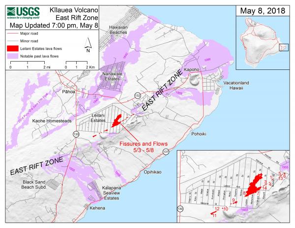
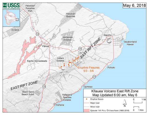
This map shows the locations of fissures and an ‘a‘ā flow erupted since May 3 in the order that they occurred in Leilani Estates as of 7:00 p.m. HST, May 8. The purple areas are lava flows erupted in 1840, 1955, 1960, and 2014-2015. (see large map)
VIDEO: Drone over Leilani Estates at Night
Contribute: Salvation Army Volcano Relief Fund
HAWAIIAN VOLCANO OBSERVATORY STATUS REPORT
U.S. Geological Survey Tuesday, May 8, 2018, 11:18 PM HST
KILAUEA VOLCANO (VNUM #332010)
19°25'16" N 155°17'13" W, Summit Elevation 4091 ft (1247 m)
Current Volcano Alert Level: WARNING
Current Aviation Color Code: ORANGE
Lower East Rift Zone Eruption
The intermittent eruption of lava in Leilani Estates in the lower East Rift Zone of Kīlauea Volcano continues. Activity today was focused on the northeast portion of the fissure area; two new fissure segments (13 and 14) broke ground between fissures 7 and 6. Fissure 13 cut across Leilani Street. By 5:00 pm, fissures 13 and 14 were inactive; late this evening geologists reported loud jetting and booming sounds, and some spattering, at fissure 13. At about 6:00 p.m. reports of booming sounds were reported in the vicinity of Black Sands Beach Subdivision. When HVO geologists arrived soon after, no such sounds were occurring.
Earlier this morning, geologists reported the widening of cracks of about 1 to 4 cm (0.4 to 1.6 in) of cracks on Highway 130 and Ali‘ili road.
Rates of seismicity changed little throughout the day, but increased during the fissure activity in the afternoon. Gas emissions remain elevated in the vicinity of fissures.
HVO field crews successfully completed the installation of two new co-located seismometers and GPS receivers on the north and south sides of the East Rift Zone. Mahalo to landowners for allowing access and use of their property. HVO geologists will be in the area overnight to track and report to Hawaii County Civil Defense on the activity, and other scientists are tracking the volcano's overall activity 24/7 using various monitoring data streams.
Residents should remain informed and heed Hawaii County Civil Defense closures, warnings, and messages (http://www.hawaiicounty.gov/active-alerts).
For maps showing the locations of eruption features, please see https://volcanoes.usgs.gov/volcanoes/kilauea/multimedia_maps.html
For information on volcanic air pollution, please see: http://www.ivhhn.org/vog/
Kīlauea Volcano Summit
Tiltmeters at the summit of Kīlauea Volcano continue to record the deflationary trend of the past week and the lava lake level continues to drop. Rockfalls from the steep crater walls into the retreating lake continue to produce occasional ashy plumes above Halema‘uma‘u crater. These plumes are expected to continue.
Earthquake activity in the summit remains elevated. Many of these earthquakes are related to the ongoing subsidence of the summit area and earthquakes beneath the south flank of the volcano.
* * * * *
HAWAIIAN VOLCANO OBSERVATORY STATUS REPORT
From U.S. Geological Survey, Monday, May 7, 2018, 5:59 PM HST
KILAUEA VOLCANO (VNUM #332010)
- 19°25'16" N 155°17'13" W, Summit Elevation 4091 ft (1247 m)
- Current Volcano Alert Level: WARNING
- Current Aviation Color Code: ORANGE
Lower East Rift Zone Eruption
The intermittent eruption of lava in the Leilani Estates subdivision in the lower East Rift Zone of Kīlauea Volcano continues. The location of activity today was focused on the southwest portion of the area.
This morning, two new fissure segments broke ground. The first (fissure 11) opened in a forested area southwest of Leilani Estates about 9:30 am and was active for only 3 hours. The second (fissure 12) opened about 12:20 between older fissures 10 and 11. By 3:15 pm, both new fissures were inactive but the west end of fissure 10 was steaming heavily.
Cracks on Highway 130 widened from 7 cm to 8 cm over the course of the day and additional cracks were found just west of the highway on trend with the eruptive fissures.
For map of recent features discussed above, see https://volcanoes.usgs.gov/volcanoes/kilauea/multimedia_maps.html
Rates of seismicity and deformation changed little throughout the day.
Gas emissions likely remain elevated in the vicinity of fissures.
Residents should remain informed and heed Hawaii County Civil Defense closures, warnings, and messages (http://www.hawaiicounty.gov/active-alerts).
For maps showing the locations of eruption features, please see https://volcanoes.usgs.gov/volcanoes/kilauea/multimedia_maps.html
For information on volcanic air pollution, please see: http://www.ivhhn.org/vog/
HVO geologists will be in the area overnight to track and report to Hawaii County Civil Defense on the activity, and other scientists are closely tracking the volcano's overall activity using various monitoring data streams.
Kīlauea Volcano Summit
Tiltmeters at the summit of Kīlauea Volcano continue to record the deflationary trend of the past several days and the lava lake level continues to drop. Rockfalls from the steep crater walls into the retreating lake continue to produce occasional ashy plumes above Halema‘uma‘u crater. These plumes are expected to continue.
Earthquake activity in the summit remains elevated but has decreased over the past few days. Many of these earthquakes are related to the ongoing subsidence of the summit area and earthquakes beneath the south flank of the volcano.
This message will be updated tomorrow morning or earlier should conditions change.
HVO Contact: askHVO@usgs.gov
MORE INFORMATION
Activity Summary also available by phone: (808) 967-8862
Subscribe to these messages: https://volcanoes.usgs.gov/vns2/
Webcam images: https://volcanoes.usgs.gov/volcanoes/kilauea/multimedia_webcams.html
Photos/Video: https://volcanoes.usgs.gov/volcanoes/kilauea/multimedia_chronology.html
Lava Flow Maps: https://volcanoes.usgs.gov/volcanoes/kilauea/multimedia_maps.html
Definitions of terms used in update: https://volcanoes.usgs.gov/volcanoes/kilauea/extra/definitions.pdf
Overview of Kīlauea summit (Halemaʻumaʻu) and East Rift Zone (Puʻu ʻŌʻō ) eruptions:
https://volcanoes.usgs.gov/volcanoes/kilauea/extra/background.pdf
Summary of volcanic hazards from Kīlauea eruptions:
https://volcanoes.usgs.gov/volcanoes/kilauea/extra/hazards.pdf
Recent Earthquakes in Hawai'i (map and list):
https://volcanoes.usgs.gov/hvo/earthquakes/
Explanation of Volcano Alert Levels and Aviation Color Codes:
https://volcanoes.usgs.gov/activity/alertsystem/index.php
https://pubs.usgs.gov/fs/2006/3139/
HVO Contact: askHVO@usgs.gov
CONTACT INFORMATION:
askHVO@usgs.gov
The Hawaiian Volcano Observatory is one of five volcano observatories within the U.S. Geological Survey and is responsible for monitoring volcanoes and earthquakes in Hawai`i.